It is useful to attach distinctive names to particular pieces of land. Apart from avoiding confusion in everyday conversation, it helps to protect owners and tenants in face of the law’s demands and those of the tax-gatherer, whether government or, in the past, the Church. More than sixty field-names have been identified in the parish of Penallt, many of them from the tithe apportionment of 1847. Each of the fields has been given a number which appears on the Key Map to Penallt Field Names (or click map below). The appropriate number appears in brackets after each name quoted in this article; a list of those not quoted is given at the end. There are four main types: those fields bearing personal names; those indicating location; those suggesting usage; and those describing appearance or characteristics.
Once a name has been attached to a piece of land, it tends to stick – it suits everyone that changes are avoided. (After six years, our home is still known in the records of British Gas as ‘Plot 13’!) it seems likely therefore than many of the personal names surviving are those of the original freeholders or tenants when the land was enclosed after the 1810 Act and legal definitions became more necessary – or, of course, from even earlier times.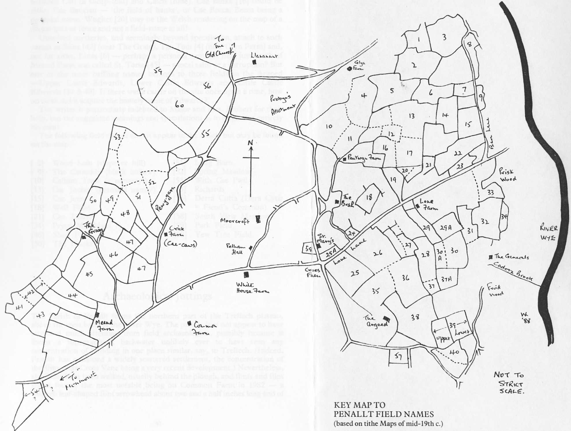
They include:
[7] Car Filly (Ffili’s Field)
[23] The Colonel’s Orchard
[26] Peggy Jones’ Field
[37A] Clifford’s Wood
[43] Captain’s Field
[44] Duke’s Piece
[47] Cae Davy
[48] Martin’s Field
[5] Cae Witty George
This last may perpetuate a local comic, or more prosaically, a mis-reading of “Willie”.
Names indicating a fields location range from the obvious
Top Meadow [11] to the more obscure
Coitia [8] – probably the effort of a non-Welsh speaker to write Coedtew (thick wood). Other examples are
Cross Vane Piece [25A] (Croes Faen – stone cross),
Maes Argoed [27] (the Argoed meadow),
Graig Field [49] and
Cae Ruin [14].
Fields names describing the use to which the land was put were more numerous in the parish:
[25] Sheepcot Field
[29A] Cae Fold
[41] Quarry Field
[35] Cider Mill Field
[37] Saw Pit Field
[38] Malthouse Field
In addition, there is Cae Pucha [22] (possibly Cae Buches – cow pasture), Cae Fruin [28] (literally “The Bridle Field”, perhaps where horses were turned out), and The Canters [57], probably Cant hir (“long hundred”) – which may be where the horses were exercised. And perhaps into this category comes The Potash [originally field no. 54, but now the name for the field across the lane to the east.] Maybe potash, a valuable fertiliser, was once produced there.
The appearance of a piece of land or its chief characteristic was uppermost in the minds of those who names the following – with all but two being Argoed land:
[1] Cockin (red land)
[29] Cae Melyn (yellow or brown field)
[30] Cae Gwyn (white field)
[31] Pullagessic (Pwll-y-gaseg – the mare’s pond)
[32] Pena Pull (Pen-y-pwll – top of the quarry)
[30A] Cae Garrows (Cae Garw – the rough field)
[36] Lena Vaur (Llain Fawr – the big patch or piece)
There is also Croes Onen [24], meaning the ashen cross – perhaps the site of a wooden wayside cross, where the track from Pen-Twyn Green meets Lone Lane; or alternatively meaning a fallen stone cross, by an ash tree. In addition, Upper Prysg [33] means ‘brushwood’, a name also used for Prisk Wood north of the Generals.
The names listed so far present few problems in understanding their origin, but the meaning of others can only be guessed. However, some of the guesses may be considered reasonable by those who can hear hidden Welsh words when the names are spoken. Thus, Cae Ba Sykeitch [17] may be a mangled version of Cae Bach Sychedig – ‘little parched field’. Clock Lain [3] may be Cloch Lain – ‘bell field’; Cae Wisha-ty [19] could be Cae Is-y-ty – ‘the field below the house’; Cae Cailth [12] gives us a choice between Cail (a sheep-fold) and Calch (lime). Cae Binka [16] could be either Cae Banciau – ‘the field of banks’, or Cae Becca, Becca being a personal name. Wughet [20] may be the Welsh rendering on the map of a wicket gate or fence and not a field-name at all!
Unsolved mysteries, and seemingly beyond speculation, attach to such names as Slina [42] (near The Graig), The Tom [4] (near Glyn Farm) and, not far away, Livas [6], perhaps a personal name. A field just north of Meend Farm was called St. Torse [45] – a local saint or a corruption? But one of the most baffling names belongs to three fields in the Argoed – Upper Castle Edwards, Lower Castle Edwards and Little Castle Edwards [39 & 40]. If there was a castle on the site once upon a time, how on earth did it acquire the homely name of Edwards?
The writer is particularly indebted to Major and Mrs Probert for their help, but the suggested meanings and speculations are entirely his own!
The following field names do not appear in the article but may be found on the map:-
| [2] | Wood Lain (slope or hill) |
| [9] | The Cwmddy (black hollow) |
| [10] | Callum Tross (a mystery!) |
| [13] | Cae Jockey (personal name?) |
| [15] | Cae Jean |
| [18] | Well Field |
| [21] | Cae Thatch |
| [34] | Prysg M. (Maes?) |
| [46] | Shed Field |
| [50] | The Phicks |
| [51] | Long Barn |
| [52] | Spring Meadow |
| [53] | With Cae Pwll |
| [55] | Richards |
| [56] | Derra Cutta (Dera Cytir = Fiends’ Common) |
| [58] | South View Meadow |
| [59] | Park Field |
| [60] | Yew Tree Field |
[from: Penallt – A Village Miscellany]