January 2018 was a little below normal as far as temperature and rainfall were concerned and the average maximum temperature of 7.8°C was 0.3°C below the Usk average for January of 8.1°C. The minimum temperature sank below 0°C on five days. The warmest days were the 2nd and 28th (max = 11.6°C) and the coldest was the 8th with a low of -1.3°C.
The measured rainfall was 89.0 mm, 70% of the Usk* average for January of 127.6 mm. Rain was measured on 20 days in the month, the wettest being the 24th when 15.2 mm fell.
February 2018 was much colder than usual, especially during the last week when we were influenced by “The Beast from the East“, and was much drier than usual also. The month had 17 frosty mornings in all, and there was one day (28th) when frost lasted throughout. Overall, the average maximum temperature of 6.5°C was 2.0°C below the Usk average for February of 8.5°C.
The warmest by day was the 19th with a maximum of 12.1°C and the coldest by night was the 28th with a low of -7.6°C.
There were 18 days on which no significant rain (0.2 mm or less) fell, and a total monthly rainfall of 33.5 mm was 38% of the Usk* average for February of 87.4 mm. The wettest day was the 13th with 9.8 mm.
March 2018 was much colder and a much wetter than usual. Overall, the average maximum temperature of 8.0°C was a huge 3.1°C below the Usk average for March of 11.1°C and there were three days of sub-zero temperatures throughout as well.
The coldest by day was the 1st, with a maximum of -3.3°C, being the middle of a three day “beast from the east” spell of blizzard conditions.
There were 23 days on which rain was recorded (>0.2 mm), the wettest being the 5th on which 22.8 mm fell. The total rainfall of 170.8 mm was just over double the Usk* average for March of 83.1 mm.
NB Rainfall figures above are underestimated due to snowfall at the beginning of the month being unrecorded.
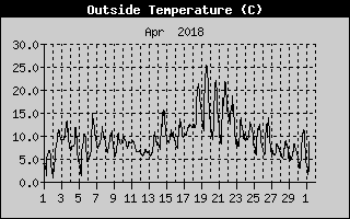 April 2018 was mostly cold and reasonably wet, but was notable for a heatwave in the middle which provided the hottest April day for some 60 years. Overall, the average maximum temperature of 13.2°C was 0.8°C below the Usk average for April of 14.0°C with a peak of 25.5°C on the 19th, the minimum temperature being 1.1°C on the 1st and the 2nd.
There were 12 days when no rain (or a trace) fell, the wettest days being 27th when 18.0 mm fell each. It was much wetter overall than usual with the total rainfall of 117.2 mm being 74% above the Usk* average for April of 67.5 mm.
May 2018 saw 18 days on which no significant rain fell. Nevertheless, the total rainfall of 92.8 mm was 30% above the Usk* average for May of 71.5 mm, much of it falling on the last eight days of the month, which were unsettled and thundery at times..
Maximum temperatures exceeded 20°C on twelve days with a high of 26.5°C on the 7th. May was very warm overall as a result, and the average maximum temperature of 19.0°C was 1.5°C above the Usk average for May of 17.5°C and, in the UK overall, May 2018 was the hottest since records began.
June 2018 was the warmest June on record in Wales and the third warmest June in the UK since 2010.
Maximum temperatures were well above average during this period, exceeding 20°C on 21 days with a maximum of 28.8°C on the 26th.
The month began and ended with warm spells and, overall, the average maximum temperature of 22.2°C was 1.9°C above the Usk* average for June of 20.3°C.
June was also a very dry month, the Penallt total rainfall of 16.0 mm being 27% of the Usk* June average of 60.2 mm. There were 20 days in the month when no measurable rain fell too.
July 2018 was hot and dry for the most part, but ended with heavy rain. The total rainfall of 73.0 mm was 17% above the Usk* average for July of 62.6 mm, most falling on the 29th (51.6 mm). Despite this, there were 23 days on which no measurable rain fell.
The average maximum temperature of 25.4 °C was 3.1 °C above the Usk average for July of 22.3 °C; there were eighteen days when the temperature exceeded 25 °C, the warmest being 30.6 °C on the 8th.
The Met Office stated that July 2018 was the second (equal) warmest July since 1910.
August 2018 was a little cooler than usual but just above average in terms of rainfall. The total rainfall of 80.8 mm was 9% over the Usk* average for August of 73.9 mm, most being concentrated in a few days and there were 23 days on which no significant rain (>0.2 mm) fell.
The average maximum temperature of 21.1 °C was 1.0 °C below the Usk average for August of 22.1 °C, the warmest day being the 5th (27.2 °C). The temperature was 20 °C or more on 19 days.
September 2018 was unremarkable overall regarding rainfall and temperature. The dry spell at the end of August continued for another 7 days and there was little substantial rain thereafter until the 20th, when nearly 50 mm fell: the total rainfall was 78.4 mm, some 97% of the Usk* average for September of 81.2 mm.
The month was cooler than average, with the mean maximum temperature of 17.8 °C being 1.4 °C below the Usk average for September of 19.2 °C. The highest was 24.4 °C on the 3rd and the lowest of a chilly 10.8 °C occurred on the 22nd.
October 2018 was of near average temperature and drier than usual. The average maximum temperature of 14.6°C was 0.4°C under the Usk average for October of 15.0°C.
There were 18 days on which no significant rain was recorded, making it a very dry month overall, and the total rainfall of 80.8 mm, was 70% of the Usk* average for October of 126.3 mm, much the wettest day being the 12th on which 43.6 mm fell, over half the month’s total.
November 2018 was drier than usual and contained an extended spell of cold weather between the 17th and 27th. The average maximum temperature of 10.3°C was 0.7°C below the Usk average for November of 11.0°C. Several days had ground frosts but the air temperature only dropped below zero on the 22nd. Maximum temperatures ranged between 13.6°C on the 6th and 4.7°C on the 21st.
Measureable rain was recorded on 23 days and there were three days when over 10 mm was recorded, the wettest being the 9th when 19.2 mm fell. The total rainfall of 84.4 mm was 74% of the Usk* average for November of 113.7 mm.
December 2018 was much milder than usual and was wetter too. The average maximum temperature of 10.1°C was 1.7°C above the Usk average for December of 8.4°C. The maximum temperature exceeded 10°C on 14 days and there were 4 days of air frost too.
It must be pointed out that data were lost for the first 22 days in the month and have been substituted by results obtained by Colin Harris in Over Monnow as the best available – for which many thanks. However, it is likely that some minimum temperatures will be significantly lower than those at Pentwyn due to temperature inversion effects, and maximum temperatures will often differ by a degree or so too, owing to the 200 m height difference between the stations.
There were 12 days when no significant rain was recorded (<0.2 mm); the total rainfall was 196.2 mm, 61% above the Usk* average for December of 121.9 mm.
Click the button below for an Excel file giving daily data for 2018:-
* Ross-on-Wye is the nearest Met Office station for which long term averages (1971-2000) are available.