January 2020 was a little warmer and a little drier than usual and the average maximum temperature of 8.6°C was 0.5°C above the Usk average for January of 8.1°C. The minimum temperature sank below 0°C on four days. The warmest day was the 14th (max = 11.9°C) and the coldest was the 21st with a low of -1.1°C.
The measured rainfall was 116.8 mm, 92% of the Usk* average for January of 127.6 mm. Rain was measured on 23 days in the month, the wettest being the 14th when 20.4 mm fell.
February 2020 was warmer than usual, and was much wetter than usual also. The month had one frosty morning. Overall, the average maximum temperature of 9.4°C was 0.9°C above the Usk average for February of 8.5°C with a maximum of 12.3°C on the 23rd.
There were 5 days on which no significant rain (0.2 mm or less) fell, and a total monthly rainfall of 242.8 mm was 2.78 times the Usk* average for February of 87.4 mm. The wettest day was the 15th with 47.4 mm.
The Met Office reports that this has been the wettest February since records began. But this is an overall statistic and conditions in Penallt may be different. For example, February 2014 saw 266.9 mm fall in Penallt.
Records began here in April 2011 and we have experienced five wetter months since then, with an all-time record of 302.1 mm in January 2014.
March 2020 was colder and a little drier than usual. Overall, the average maximum temperature of 10.2°C was 0.9°C below the Usk average for March of 11.1°C.
The coldest by day was the 19th, with a maximum of 4.8°C, and the warmest was the 24th with a maximum of 16.7°C.
Unusually, rain fell on every one of the first 19 days but on none of the remaining 12. The total rainfall of 78.8 mm was 95% of the Usk* average for March of 83.1 mm.
April 2020 had two long dry spells and was much warmer than usual overall too. Overall, the average maximum temperature of 16.7°C was 2.7°C above the Usk average for April of 14.0°C with a peak of 24.7°C on the 11th, the minimum temperature being 0.1°C on the 1st and there were no air frosts. There were 7 days on which the temperature exceeded 20°C.
There were 23 days when no rain (or a trace) fell, the wettest days being 18th when 18.6 mm fell each. It was drier than usual overall with the total rainfall of 54.4 mm being 81% of the Usk* average for April of 67.5 mm.
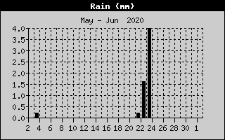 May 2020 was the second driest month in Penallt since records began in mid-March 2011 (April 2011 was the driest with a total of 5.0 mm). The month saw only 2 days on which significant rain fell. The total rainfall of 6.2 mm was 9% of the Usk* average for May of 71.5 mm.
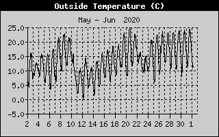 Maximum temperatures exceeded 20°C on 14 days with a high of 25.2°C on the 20th. May was a very warm and sunny month overall, and the average maximum temperature of 19.0°C was 1.5°C above the Usk average for May of 17.5°C.
June 2020 had a hot spell which brought the mean temperature to the usual value and was wetter than normal too.
The average maximum temperature of 20.0°C was 0.3°C below the Usk* average for June of 20.3°C and there were 13 days when 20°C was exceeded. The maximum was 30.7°C on the 25th, just 0.1°C below the Penallt June record set in 2017.
June had two very wet days which brought the Penallt total rainfall to 101.1 mm, being 68% above the Usk* June average of 60.2 mm. The wettest day was the 18th, with a fall of 39.2 mm. There were 16 days in the month when no measurable rain fell too.
July 2020 was cool and dry for the most part, but ended with a mini-heat wave. The total rainfall of 38.2 mm was 61% of the Usk* average for July of 62.6 mm, with no really wet days, the worst being the 19th when 6.4 mm fell. There were 18 days on which no measurable rain fell.
The average maximum temperature of 20.5 °C was 1.8 °C below the Usk average for July of 22.3 °C; there were only two days when the temperature exceeded 25 °C, the warmest being 30.8 °C on the 31st.
August 2020 was a little cooler than usual and well above average in terms of rainfall. The total rainfall of 148.6 mm was double the Usk* average for August of 73.9 mm and there were 15 days on which no significant rain (>0.2 mm) fell. On the other hand, rainfall exceeded one inch (25.4 mm) on two days, the 25th (28.6 mm) and the 27th (27.4 mm) and the second half of the month was much wetter than the first half.
The average maximum temperature of 21.4 °C was 0.7 °C below the Usk average for August of 22.1 °C. As for rainfall, the first half of the month was much warmer than the second and a 6-day heatwave starting on the 7th culminated in a record Penallt high of 33.2 °C on the 12th.
The second half of August was about 5 °C cooler than the first half with the last five days being particularly autumnal in feel, a maximum of under 15 °C on the 27th being the lowest point.
September 2020 was settled for the most part with nearly three weeks of dry weather which broke on the 23rd with much cooler and wetter conditions. It was dry overall, the total rainfall being 39.0 mm, only 48% of the Usk* average for September of 81.2 mm. There were 21 days of rainfall of 0.2 mm or below. The wettest day was the 24th, when 14.6 mm fell.
The month was a little cooler than average, with the mean maximum temperature of 18.7 °C being 0.5 °C below the Usk average for September of 19.2 °C. The highest was 25.9 °C on the 14th and the lowest of 12.1 °C occurred on the 24th. The temperature exceeded 20 °C on 9 occasions.
October 2020 was much cooler and wetter than usual. The average maximum temperature of 12.9°C was 2.1°C under the Usk average for October of 15.0°C.
There were 9 days on which no significant rain was recorded and the total rainfall of 173.2 mm was 37% above the Usk* average for October of 126.3 mm. Over 40% of the rain (74.2 mm) fell on the three days 2nd, 3rd and 4th.
November 2020 was average for temperature and rather drier than usual. The average maximum temperature of 11.0°C was the same as the Usk average for November of 11.0°C. Several days had ground frosts but the air temperature only dropped to zero on the 27th. Maximum temperatures ranged between 15.6°C on the 1st and 4.6°C on the 27th.
Measurable rain was recorded on 18 days and there was one day when over 10 mm was recorded, the wettest being the 11th when 12.4 mm fell. The total rainfall of 89.0 mm was 78% of the Usk* average for November of 113.7 mm.
December 2020 was colder than usual and was much wetter than average too. The average maximum temperature of 7.5°C was 0.9°C below the Usk average for December of 8.4°C. The maximum temperature exceeded 10°C on 7 days and there were 6 days of air frost too with the month ending with a cold spell.
There were 9 days when no significant rain was recorded (<0.2 mm). But these were accompanied by some very wet days (7 days with more than 10 mm) and the total rainfall was 257.4 mm, was 111% above the Usk* average for December of 121.9 mm.
This made it the wettest month since February 2014 (266.9 mm) and only the fourth time since April 2011 that 250 mm has been exceeded, the record being January 2014 (302.1 mm).
The 23rd was the wettest day with 54.8 mm, the third highest daily total since records started in April 2011 and only the fifth occasion on which 50 mm (just under 2 inches) has been recorded.
Click the button below for an Excel file giving daily data for 2020:-
* Usk is the nearest Met Office station for which long term averages (1981-2010) are available.