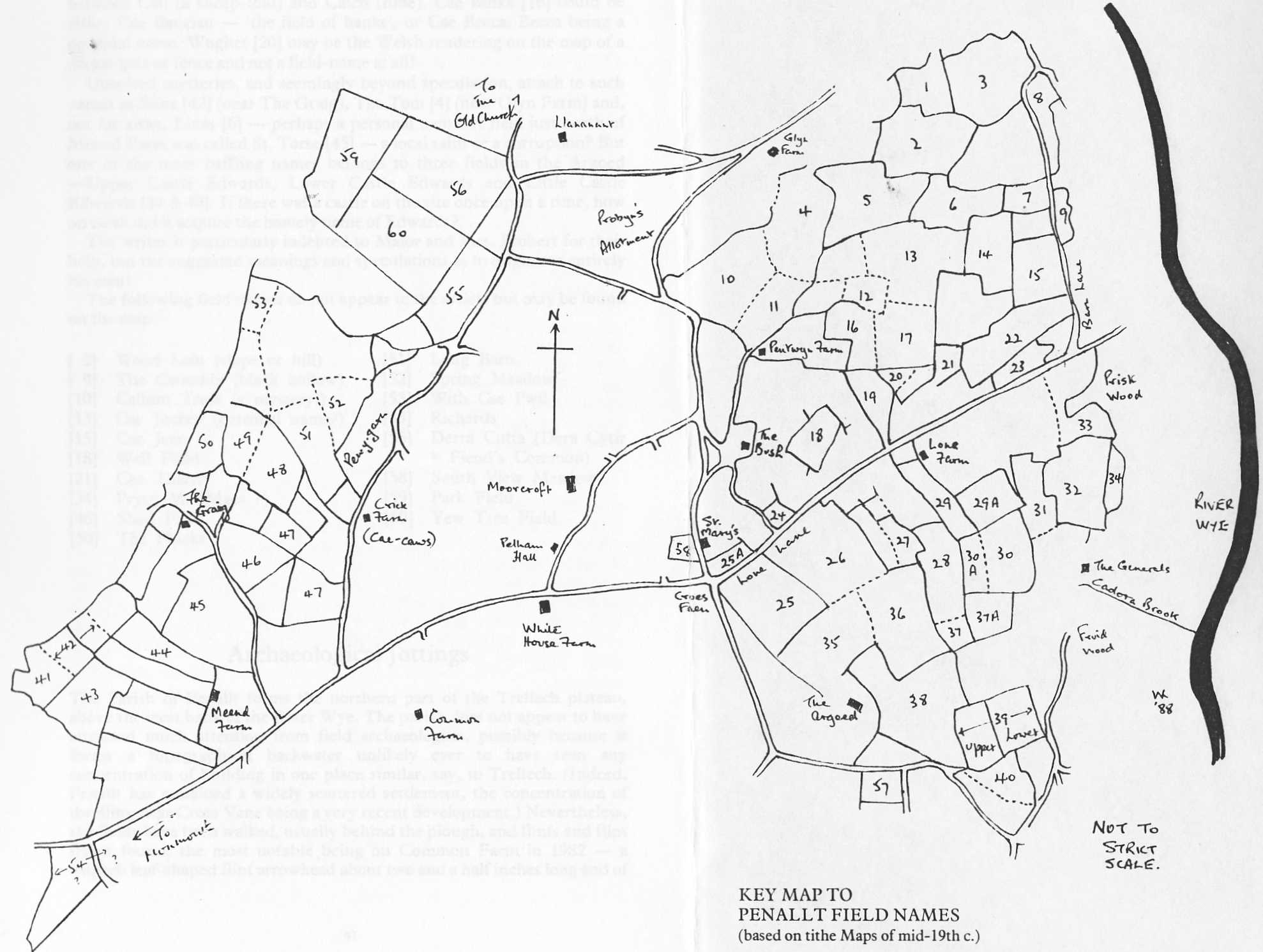
More than sixty fields in the parish were identified and recorded by name when the detailed survey was undertaken in the 1840’s to support a register of land owners required to pay tithes.
The Miscellany included (page 39 to 41) a review of these names and their probable origins together with a sketch-map based on 1847. That map is reproduced here and the names in the register listed below, with their Welsh language origins both obvious and “best guesses” where we think they can be recognised
| 1 Cockin (red land) | 30A Cae Garrows (Cae Garw = rough field) |
| 2 Wood Lain (slope) | 31 Pullagessig (Pwll-y-gaseg = the mare’s pond) |
| 3 Clock Lain (Cloch = bell) | 32 Penapull (Pen-y-pwll = top of the quarry) |
| 4 The Tom (sic) | 33 Upper Prysg = (brushwood) |
| 5 Cae Witty (Willy) George | 34 Prysg M (Maes?) |
| 6 Livas (a personal name) | 35 Cider Mill Field |
| 7 Cae Filly (Ffili’s field) | 36 Llena Vaur (Llain Fawr = the big piece) |
| 8 Coitia (Coedtew – thick wood) | 37 Saw Pit field |
| 9 The Cwmddy (Black Hollow) | 37A Clifford’s Wood |
| 10 Callum Tross | 38 Malthouse Field |
| 11 Top Meadow | 39) Upper, Lower and … |
| 12 Cae Cailth (Cail = sheepfold, or Calch = Lime) | 40) Little Castle Edwards |
| 13 Cae Jockey | 41 Quarry Field |
| 14 Cae Ruin | 42 Slima |
| 15 Cae Jean | 43 Captain’s Field |
| 16 Cae Binka (CaeBanciau = field of banks or Cae Becca, a personal name) | 44 Duke’s Piece |
| 17 Cae Ba Sykeitch (Cae Bach Sychedig = little parched field) | 45 St. Torse (?) |
| 18 Well field | 46 Shed Field |
| 19 Cae Wisha-ty (Cae-is-y-ty = field below the house) | 47 Cae Davy |
| 20 Wughet (Welsh rendering of “wicket”) | 48 Martin’s Field |
| 21 Cae Thatch | 49 Graig Field |
| 22 Cae Pucha (Cae Buches = Cow Pasture) | 50 The Phicks (?) |
| 23 The Colonel’s orchard | 51 Long Barn |
| 24 Cross Onen(Ashen cross) | 52 Spring Meadow |
| 25 Sheepcot Field | 53 With Cae Pwll |
| 26 Peggy Jones Field | 54 The Potash (where fertiliser was made or stored) |
| 27 Maes Argoed | 55 Richards |
| 28 Cae Fruin (Bridle Field) | 56 Derra Cutta (Dera Cytir = Fiends Common) |
| 29 Cae Melyn (Yellow Field) | 57 The Canters (Cant hir = long hundred) |
| 29A Cae Fold | 58 South View Meadow |
| 30 Cae Gwyn (White Field) | 59 Park Field |
| 60 Yew Tree Field |
Information more recently coming to light enables the empty centre of the map (roughly the area called Pentwyn) to be filled with field boundaries. The following lists and locates those fields and properties given names in the 1847 register.
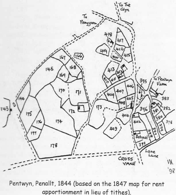
143 “Cottage and garden called Cae Cause” (Caws = cheese or Cawsi = causeway)
145 “Old Land, top of the hill.”
172 “House, garden and homestead” (“Cae Pwll Du” – Black Pit Field)
174 “Lower Cae Drellys (Drwgllys = literally Black Slime Field)
175 “Penny Gardens Meadow” (a corruption of Pen-y-Garn = the hill top with/by a cairn)
178 “Upper Cae Drellys”
378 “Lower Well Field
379 “Grass Green”
396 “Cae Cant” (Field at the Edge or Rim)
399 “Cross Vane Piece” (Croes Faen = stone cross)
408 “Far Piece”
419 “Piece at Pentwyn”
Best guesses as to today’s names of the properties shown on this map are:
| 143 Crick Farm |
| 172 Moorcroft House |
| 411 The Old Post Office |
| 412 Pengellyn |
| 405 Little Pentwyn |
| 402 Cae Lles |
| 383 The Bush Inn |
| 395 Pentwyn Green |
| 418 Greenways |
The 1847 register lists few field names towards the north and south of the parish – the areas north of Llananant and the Glyn and in Tregagle south of the Argoed. Those that do appear have such mundane names as Five Acres and Well Field (immediately north of the Old Church).
The same is true of an area to the east, the Washings, where numerous small orchards are listed as such. However, the area south of the Washings is of interest because it includes a narrow strip of land, bordering the Wye identified as the site of the vanished St. Denys Chapel and listed in 1847 as Chapel Meadow – field nos. 530/531 in the sketch map. Other named fields between Barn Lane and the Wye also shown in this map are listed below. (St Denys Chapel is the subject of a separate article with the relevant section of the “Tithe Map”).
| 295 Lower Redbrook Meadow |
| 296 Little Redbrook Wood |
| 301 House, garden & orchard (Boat Inn) |
| 302 Lower Lugas |
| 307 Sidelong Field (alongside Barn Lane) |
| 523 House and garden (Cae Dee?) |
| 524 Orchard and pond |
| 525 Old Orchard |
| 526 Cottage and garden |
| 527 House and garden |
| 532 Garden |
| 533 House, buildings and Plick (sic) |
| 534 Grist mill and orchard |
There are no entries in the register for fields numbered 528, 535 and 541.
The 1847 map and sketch maps based on it which are reproduced here are not strictly to scale and of course some boundaries have disappeared or changed during the intervening years.
[from: Penallt Revisited]